
MITIGATION OF FUTURE FLOODING OF BALLINA TOWNSHIP AND ITS SURROUNDS
By: Kevin Loughrey BE Mech (hons)
Date: 1 April 2022 (first commenced)
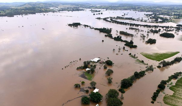
Fig 1. Ballina Flood March 2022 — Click on picture to enlarge
Background
There were a number of factors that contributed to the significant flooding in the coastal areas of the Ballina Shire which occurred around 2 March 2022. All of them point to very poor management by Government. In this paper, I will take you through the facts pertaining to this situation where Ballina, in particular, suffered the most serious flooding it had experienced since the flood of 1954. There had been subsequent lesser, yet significant, floods in 1974 and 1989. The most prominent and seriously affected town has always been Lismore. The worst flood of all occurred in the late 1890's. Following the 1989 flood where Lismore was very badly affected, the concept of a levee to protect the CBD was raised by those opposed to building dams in the catchment areas to provide an effective means of flood mitigation. These persons who were effectively members of the Greens Party had been elected to Council which then tainted any suggestions that would require development. After an extensive hydrological investigation which deliberately left out the option of building dams in the catchment area and costed the taxpayers millions of dollars, there was a decision made to construct a limited levee system, which eventually cost approximately $21 million, around South and Central Lismore. In other words, the investigation gave justification for wasting money on the levees rather than providing a permanent solution to the flooding for not only Lismore but all of the surrounding areas. These levees have proven to be abject failures as much as those who constructed them have tried to trumpet their usefulness. In March 2017, the Lismore flood levee failed and that sudden failure caused significant destruction to property because residents thought the levees would provide protection from serious flooding and because there had been considerable development in that area compared to the early days of settlement. Rather than give priority to building dams and doing things that would actually prevent flooding, the Lismore City Council launched its Flood Ready project at huge cost to the tax and rate payers. In doing this it developed a comprehensive, community-wide action plan in the hope it would be able to better cope with the next flood. As so often happens with Government bureaucrats, this plan did little or nothing to prevent the next disaster in March of 2022.
Historical Rainfall Records
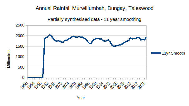
Fig 2. Rainfall in Murwillumbah 1954 to 2021 — Click on Picture to Enlarge
The Spectre of "Climate Change". Before proceeding further on the subject of flood mitigation, I thought I should deal briefly with the subject of "Climate Change"; something which is code for "Antropogenic Global Warming" - the hypothesis that the earth's atmosphere is warming dangerously because of human emissions of Carbon Dioxide (CO2), Methane CH4 and Nitrous Oxide (NO). Those that are concerned about the prospect of climate change then use that as a pretext for extraordinary action, invariably involving people having to change their present behaviour, endure additional expenditure and/or be denied the use and, sometimes, possession of their property. In the case of flooding in the Northern Rivers Area, adherents of climate change have asserted that development in areas prone to occasional flooding should be banned and that, in some cases, those people living in these areas should be relocated. These same people are invariably, for a range of reasons, strongly opposed to flood mitigation measures that would involve the building of dams or diversion of flood waters. They maintain that flooding is becoming more extreme because of the burning of fossil fuels and so it is worthwhile to briefly examine historical records relating to rainfall and flooding in the Northern Rivers area to see whether their assertions have any grounding in fact.
Murwillumbah Annual Rainfall Record. To the right is a graph (Fig 2.) of annual rainfall from 1951 to 2021 in the Murwillumbah region where the Bureau of Meteorology has a rain measuring station. You can see that, if anything, rainfall has tapered off slightly.
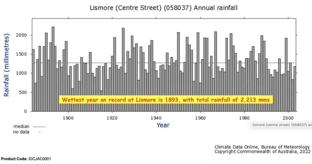
Fig 3. Lismore Annual Rain 1880-2022 — Click on Picture to Enlarge.
Lismore Annual Rainfall Record. Similarly the historical data from Lismore shows rainfall remaining the same or decreasing ever so slightly.
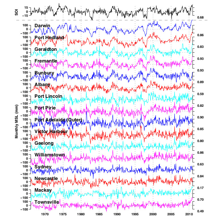
Fig 4. Historical Tide Gauge Record For Australia — Click on Picture to Enlarge
Historical Tide Gauge Record 1965-2012. From the tide gauge record taken from tide gauges around Australia, it can be seen that the sea level is not rising precipitately. People who blame recent flooding on rising sea levels are simply ill-informed.
Conclusion on "Climate Change". As a consequence of this data from both Lismore and Murwillumbah, we can conclude that any suggestion the climate is changing such that extreme weather events are becoming more frequent is not valid and may, in fact, simply be people:
- espousing a popular narrative out of ignorance of the historical facts,
- promoting a particular agenda in order to achieve a political advantage,
- trying to gain a material benefit, or
- attempting to deflect blame for their incompetence or the incompetence of those with whom they are associated.
Heavy rains and flooding has always been a feature of life in the Northern Rivers. The former is unavoidable but the latter can be addressed such that floods are mitigated to the extent they do not cause widespread destruction of land and housing. It is important that people appreciate that flooding does not just destroy property, it results in largescale soil erosion. This has been happening for millions of years before modern-day settlers arrived in this area. It is within our capabilities to reduce the extent of this soil erosion to the great benefit of the environment and farming capability in this area.
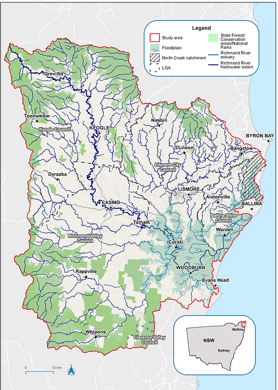
Fig 5. Areas Affected by Floods — Click on Picture to Enlarge.
Actions that would reduce Flooding and Property Damage
There were a number of factors that contributed to the significant flooding in the coastal areas of the Ballina Shire which occurred around 2 March 2022. All of them point to very poor management by Government. Here is a list of those things that could be done and should have been done a long time ago to mitigate or even obviate the likelihood of severe flooding as a consequence of heavy rainfall:
- Build Dams in the Catchment Areas. No significant dams have been built in catchment areas throughout Australia for well over 70 years yet the need for these dams has been well appreciated. (Mayor Sharon Cadwallader's petition in 2021 showed a strong level of public support for the construction of Dunoon Creek Dam.) Not only are these dams needed for flood mitigation but also for water security for a growing population in the Northern Rivers. Dunoon is but one of a number of dams that need to be constructed in the catchment areas of the Northern Rivers generally. If these dams had been constructed, it would have been possible, with proper management, to mitigate the effects of the heavy rainfall. Large-scale flooding has always been a feature of life in the Northern Rivers. There is always a lot of talk but nothing ever gets done to remedy this. Persons who are opposed to the building of dams often resort to conservation issues such as, in the case of Dunoon Dam, a colony of Koalas in that area or the preservation of Aboriginal Sacred Sites. These issues are not insurmountable. The Koalas can be relocated and the matter of sacred sites has to be addressed by a general realisation that sacred sites and superstitions held by certain groups within a society cannot interfere with the needs of the greater community.
- Real Time Reporting of Rainfall. If the Bureau of Meteorology installed real time rain gauges in the catchment area, it would be possible to accurately compute the amount of rain that had fallen and the amount that was falling in real time. By measuring the height of reference creeks and rivers as this rain falls, it would be possible, over time to construct an accurate relationship between the amount of water that falls and the amount of flooding that results. The present hydrological models are believed to be of doubtful accuracy. Real data would remedy this and put matters beyond doubt. This includes quantifying the characteristic where, after a long period of rain, the earth becomes saturated so that additional rain has a stronger flooding effect.
- Webpage for Flood Information. This system could be linked to a web page where information is provided graphically, in an easily understood form, to alert locals as to the present and likely future flooding in real time. This would significantly reduce losses sustained by the farmers and local people. People could have moved valuable items to higher ground and made better preparations for what was to come if there was in place an effective, accurate early warning system.
- Divert Surplus Water Inland. Australia has a modest mountain range running down its entire East Coast. It is called "The Great Dividing Range"; "Great", not because it is high but because it runs for many thousands of kilometres. Indeed, Australia is the flattest, driest continent on earth with the thinnest covering of topsoil. On the Eastern side of this range there is often plentiful rain whereas on the Western side it is comparatively dry with deserts being a common feature of inland Australia. In the 1930's, a scheme was conceived and was completed in the early 1970's. It is called, "The Snowy Mountain Scheme". It was a scheme designed to provide low cost electricity to satisfy peak demand on the East coast, largely through a process known as "pumped hydro", as well as taking water from the Australian Alps in the Southern part of the Great Dividing Range and sending it inland where it provides water to the Murrumbidgee Irrigation Scheme; an area that provides a great deal of primary produce to the population of Australia. The produce from this area is also exported, sometimes as a finished product as is the case with wine. It was envisaged there would be similar schemes up the Eastern coast of Australia but because of incompetence, dim-wittedness and environmentalists, these schemes have never been executed. In Northern New South Wales, there is frequent heavy rainfall. The recent flooding could have been avoided if the floodwaters were diverted inland to the other side of the Great Dividing Range. Given advances in tunnelling technology, this scheme would not be prohibitively expensive but would, over, say, 100 years, easily pay for itself in terms of increased agricultural output plus provide primary producers some level of protection against the effects of extended drought.
- Dredge the Mouth of the Richmond River. The mouth of the Richmond River hasn't been dredged since 1998. As a consequence, floodwaters coming down the Richmond cannot easily escape out to sea. Some people, not understanding basic hydrology, have wrongly asserted that the water could not flow out because of king tides. That is incorrect. Regardless of tides, any obstruction in the River will slow down flow and result in a banking up of water upstream. The tailings from this dredging operation could be used to build up river bank on the Southern side of the river and the area inland from that. This would then facilitate the construction of a track to allow people to travel to South Ballina Beach for recreation. At the moment that road/track is closed because of subsidence.
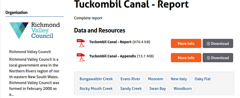
- Open the Tuckombil Canal. The Tuckombil canal was constructed to redirect floodwater coming down the Wilson River into the Evans River where it would then go directly to Evans Head and out to sea. This canal was closed off by environmentalists. The consequence of this has been largescale flooding of Ballina and the surrounding areas. It is should be of concern to all who have an interest in this matter that the NSW Government commissioned a report on the Tuckombil Canal and that report with its associated data is not freely available to the public. Why would this be the case?! (See Figures 6 & 7) Those persons who were responsible for the obstruction of the Tuckombil Canal should be the subject of a class action initiated by those who have sustained largescale property losses because of this thoughtless decision. It's time people were made to be responsible for their actions and policies.

Fig 6. Tuckombil Canal Report Request Download — Click on Picture to Enlarge.

Fig 7. Tuckombil Canal Report Result to Request — Click on Picture to Enlarge.
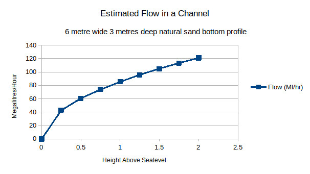
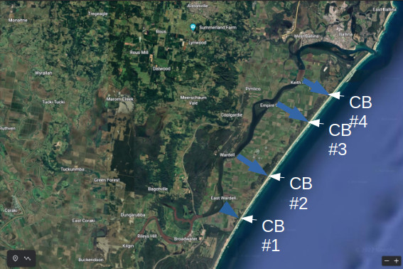
- Construct "Circuit Breakers" – Diverting Flood Waters Directly to Ocean. Figure 8 provides an estimate of the flow that could be expected in an open channel cut through the sand in a canefield. Figure 9 shows a map of the Ballina area. At the top right hand corner is the Ballina township. In the middle bottom is the town of Broadwater with the Richmond River flowing almost parallel to the coast line from Broadwater to Ballina. From the River at opportune points, where culverts exist under River Drive, it would be possible to bulldoze & dredge sizeable canals running directly to the sea. On the coastline, these canals could terminate in concrete pipes which would lead out into the ocean. At each end of the canal could be flood gates and sumps with trash-grates for maintenance. These flood gates would allow, as the present gates in that area already do, a means for draining the land for the benefit of agriculture (and hence the farmers that own that land). Circuit Breaker # 1 (CB#1) builds on an existing creek, "Boundary Gully Creek". Likewise CB#2 is in the area of "Swampy Creek" and so it goes. If these flooding circuit breakers were installed, not only would it be to the benefit of landowners, it would also allow flood waters to escape to the ocean before reaching Ballina township.
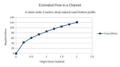
Fig 8. Estimated Flow In Channel — Click on Picture to Enlarge.
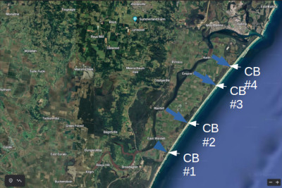
Fig 9. Concept of Proposed Circuit Breakers — Click on Picture to Enlarge.

Additional Influences
There is one other possible factor that may have influenced the degree of flooding in the area from Broadwater to Ballina and that is the construction of the new highway. Some people are of the opinion that there is the possibility that water flowing off the Eastern slopes may have been held up by the new highway acting as a levee. The highway does have a number of culverts to allow water to escape but some people are of the opinion that these culverts were either insufficient or clogged with vegetable matter that impeded the flow of the water. The result of this obstruction was that water from the Eastern slopes, which would have otherwise been dissipated, arrived in the Ballina area, between Wardell and Ballina CBD, at same time as the flood waters from Lismore; in which case there was an amplification of the flooding. This needs to be investigated by civil engineers responsible for main roads design and construction.
Conclusion
It is concluded that the recent flooding resulted from years of inaction and dithering by State and Local Governments. Development in the Northern Rivers is inevitable. Up to now conservationists and those that wish to maintain Ballina and surrounding environs as a rural out of the way place have contributed to the losses that these same people and their fellow citizens have now incurred. I believe these persons should be the subject of a class action so that people come to realise their stupidity and selfishness has consequences. It is time for some positive action. There have been countless reviews and studies of the situation in this area but instead of action the public have been subjected to secrecy and the political manoeuvring of self-serving interest groups.
It is time for a change. The above suggestions are self-evident and obvious. Each of these suggestions would reduce flooding and reduce the losses people are likely to suffer in the future. There have been enough reviews and studies. It is time for action.
Recommendations
It is recommended that:
- Dredging of the Richmond River. Various parts of the Richmond River should be continuously dredged to ensure that floodwaters are not obstructed when travelling to the Ocean. This is particularly the case with the mouth of the river.
- Tuckombil Canal. The report on the Tuckombil Canal should be freely available to the public. There is no excuse for this secrecy. The canal should either be permanently open or have in place a means where it can be opened so as to allow unimpeded flow of water in the event of heavy rain and flooding of the Wilson River.
- Real Time Rain Gauges and Flood Website. A network of rain-gauges and water-level gauges should be installed in the catchment areas such that it is possible to accurately quantify and predict the flooding that will occur as a consequence of this rainfall. A website should be constructed and notified to all residents so that early warning can be given and people may make timely preparations. This necessary infrastructure would also provide very accurate data for future flood mitigation planning.
- Construction of "Circuit Breaker"/Diversionary Canals. There should be constructed a series of diversion canals leading from the Richmond River directly to the Ocean. Given the flat, sandy nature of the terrain, this would be an ideal task for a bulldozer/excavator and large floating dredge.
- Investigate Effect of Highway and make Changes as deemed Necessary. Civil engineers, expert in design and construction of main roads, should perform an investigation to ascertain if the road delayed the exit of flood waters from the Eastern slopes thereby adding to the floodwaters arriving from Lismore. If this is the case, then engineering works should be undertaken to improve the flow of water from the Eastern slopes to the ocean.
- Construction of the Dunoon Dam, The construction of this dam should start immediately and other dams in the catchment area should be planned now; not put off for another day.
- Diversion of Water Inland. This is a much more ambitious project but it is now, because of advances in tunnelling technology, far easier and more affordable than ever before. It should be given urgent consideration when building the dams. Such a project may also be able to provide hydroelectricity to satisfy peak power demands; thereby reducing the cost of electricity to residents in the Northern Rivers.
- End of Paper -